
Restore Raritan Bay & Sandy Hook Bay, NJ


We need your help!
HELP US RESTORE RARITAN BAY AND SANDY HOOK BAY WATERSHED!
Join us for a bayshore regional watershed meeting. Meetings are always informal and a great way to learn about the Raritan Bay & Sandy Hook Bay watershed.
We meet the second Thursday of every month at 8:00pm inside Keyport Borough Hall located on Front Street. Directions can be found here.

Map of the Boundary Line between the States of New York and New Jersey from the Joint Boundary Commission Report dated October 12, 1887
Since 2000, Volunteers with the Bayshore Regional Watershed Council and Save Coastal Wildlife have been dedicated to improving water quality and restoring wildlife habitat along Raritan Bay and Sandy Hook Bay in new jersey.

1795 Map of Raritan Bay & Sandy Hook Bay
Raritan Bay and Sandy Hook Bay are tidal estuarine waters located at the southern portion of Lower New York Bay, downstream from New York City, and part of one of the mot urban coastlines in America.
Raritan Bay is named after the “Raritans,” a branch or a group of the Lenape native people who lived near the bay for many years prior to the arrival of Dutch, English and other European colonists in the 17th century.

Cornelius Hendrickson, an admiral in the Dutch Navy, made the above map in 1616 of present-day New Jersey, Sandy Hook Bay, and New York Harbor
The Influence of Dutch in New York Harbor during the early and mid 17th century is still felt today. Sandy Hook Bay is named from the Dutch during the 17th century, primarily from Cornelius Hendrickson’s 1616 map. The name stems from what the Dutch called: “Sant Hoek.” Sant means sand in the Dutch language and Hoek is defined as corner, angle, nook or point of land.
With the arrival of the English in the latter part of the 17th century, the name Sant Hoek was slightly altered to Sandy Hook since the place represented to many English sailors as a curved or bent piece of sandy land.

1872 Map of Raritan Bay & Sandy Hook Bay, New Jersey
All the land in northern Monmouth County and southeastern Middlesex County (around 60 square miles) drains to Raritan Bay via countless creeks, wetland areas, and groundwater. Additional water drains from northeastern New Jersey, most of New York City and eastern New York State into Raritan Bay. Oh boy, that's a lot of water!
Because water does not follow political boundaries, it makes sense to manage water quality on a watershed basis. When a creek, lake, river, or wetland is in trouble, one of the first things a water quality specialist will do is look at what is going on in the watershed. An action plan is developed to assist people in changing from harmful watershed activities to ones that are more water friendly
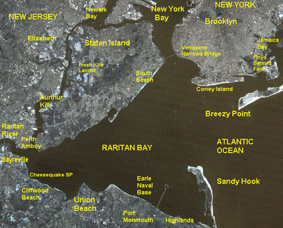
The entire Raritan Bay & Sandy Hook Bay watershed area covers two states - New Jersey & New York, and several counties including Monmouth and Middlesex in New Jersey, and Richmond County or Staten Island in New York.
Our membership includes citizens, scientists, surfers, swimmers, kayakers, boaters, beachcombers, anglers, crabbers, gardeners, and public officials from 13 communities that make up the sub-watershed region in Monmouth and Middlesex counties in New Jersey: Aberdeen Township, Borough of Atlantic Highlands, Borough of Keansburg, Hazlet Township, Borough of Highlands, Holmdel Township, Borough of Keyport, Borough of Matawan, Middletown Township, Old Bridge Township, Borough of Sayreville, City of South of Amboy, and Borough of Union Beach.
There is much to do and we need to work together to improve our waterways for future generations to enjoy. We believe the time is now to create a new Bayshore region for the 21st century. We need to work with everyone to create a sustainable and wisely-managed watershed region that does not sacrifice our wetlands, waterways, and natural areas for the sake of growth. We need to better manage our land and protect the watershed from poorly planned development. All this and more if we are to preserve unique natural areas and bay culture of our estuarine environment along Raritan Bay & Sandy Hook Bay. In short, we need you!
1884 Sandy Hook Bay Topographic Map